Storm Henk London: Met Office issues amber wind warning with 80mph gusts expected

and live on Freeview channel 276
Storm Henk is set to bring a spell of very strong winds to parts of the UK causing disruption to travel and power supplies, the Met Office has warned.
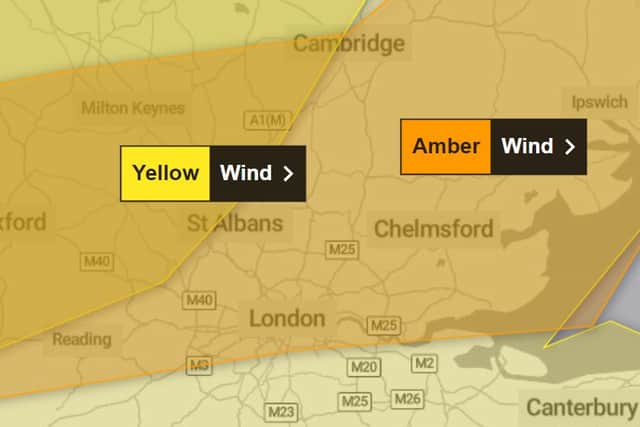
An amber severe weather warning for wind has been issued for parts of southern England, including much of London, from 10am on Tuesday (January 2) through to 8pm.
Advertisement
Hide AdAdvertisement
Hide AdStorm Henk has been forecast to bring gusts of up to 80mph to parts of the UK, the Met Office has said. The gusts of up 70-80mph are likely on exposed coasts in the west, with gusts of 50-60mph expected inland.
A yellow warning for rain has also been issued for parts of England and Wales as further rain moves in through the day.
The amber wind warning covers London, but the Met Office is currently forecasting winds reaching 48mph at about 4pm. The rain is expected to clear by early afternoon. Temperatures could reach 13°C.

Met Office chief meteorologist Paul Gundersen said: “Further wet and windy weather is forecast for the UK this week. Our latest analysis of the forecast shows an increase in the likelihood of very strong wind gusts across parts of southern Wales and England which is why we have issued this Amber warning this morning and named it Storm Henk.
Advertisement
Hide AdAdvertisement
Hide Ad“Storm Henk will initially bring very strong winds to the southwest of England and Southern Wales, with gusts of up to 80mph possible. As Storm Henk moves north-eastwards across the south of the UK through Tuesday the strongest winds will also move eastwards, across the south Midlands, Home Counties and East Anglia through the afternoon and evening.”
What to expect with an amber weather warning
- There is a good chance that power cuts may occur, with the potential to affect other services, such as mobile phone coverage.
- Probably some damage to buildings, such as tiles blown from roofs.
- Longer journey times and cancellations likely, as road, rail, air and ferry services may be affected.
- Flying debris is likely and could lead to Injuries or danger to life.
- Some roads and bridges likely to close.
- Injuries and danger to life is likely from large waves and beach material being thrown onto coastal roads, sea fronts and properties.
Comment Guidelines
National World encourages reader discussion on our stories. User feedback, insights and back-and-forth exchanges add a rich layer of context to reporting. Please review our Community Guidelines before commenting.