London weather forecast: Met Office issues fog weather warning and temperatures set to plummet to -3°C

and live on Freeview channel 276
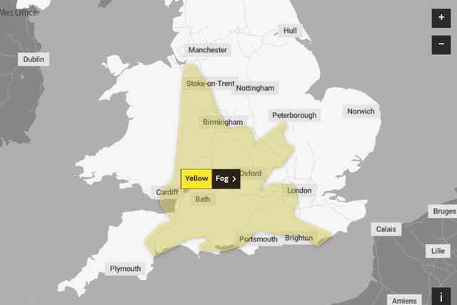
The Met Office has issued a yellow weather warning that covers much of the south including London.
Advertisement
Hide AdAdvertisement
Hide AdThe warning is from today at 5pm until Friday 14 January 11am.
The Met Office has said that the fog will cause some disruption, and asks the public to take care when travelling: “Fog patches will form during the evening and then become more widespread overnight - perhaps leading to some travel disruption”
The Met Office has advised on what the general public can expect from the upcoming weather:
“Slower journey times with delays to bus and train services possible. As well as a chance of delays and cancellations to flights.”

Tonight
Advertisement
Hide AdAdvertisement
Hide AdThere will be largely dry weather with clear skies and some light winds. The clear skies will leave room for frost to develop as temperatures drop to a minimum of -3°C.
Some areas will experience mist and fog.
Friday
Friday will start off frosty, but will be mainly sunny. For some areas the fog may be stubborn to clear in western areas.
Temperatures will be a maximum of 6°C.
Outlook for Saturday to Monday
Saturday and Sunday will be mostly dry but chilly and cloudy at times. There will be patches of mist and fog slowly clearly in the mornings.
Monday will be dry with some prolonged sunny spells to kick off your week.
UK long range weather forecast
(Monday 17 - Wednesday 26 January)
Advertisement
Hide AdAdvertisement
Hide AdTemperatures for this period are expected to be average for this time of year, slightly colder in the northern areas of the country.
Most of the unsettled weather will hit north eastern areas, with the south experiencing dry weather with light winds and clear skies.
Low pressure could move eastwards later in this period bringing strong winds and wintry showers to windward coasts.
Temperatures are most likely to stay normal for southern areas with the possibility of short colder spells.
Comment Guidelines
National World encourages reader discussion on our stories. User feedback, insights and back-and-forth exchanges add a rich layer of context to reporting. Please review our Community Guidelines before commenting.