TfL: London Tube stations set for Google Street View - list including King’s Cross, Euston and Waterloo

and live on Freeview channel 276
London’s busiest Tube stations will be accessible on Google Street view by next year, Transport for London (TfL) has announced.
Around 30 Underground stations will be added to the online service to help customers better plan their journeys.
Advertisement
Hide AdAdvertisement
Hide AdThe project will use cameras that capture 360-degree images inside the stations including Green Park, King’s Cross St Pancras and Waterloo.
Google will start collecting Street View imagery, in the coming weeks with posters placed at stations to alert customers when imagery capture may occur.
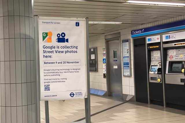

The images will be collected by Google staff between 10am and 4pm to avoid peak hours, using a 360-degree backpack camera. Faces will be blurred before publication.
The images will go online throughout 2024, allowing customers to explore stations.
Advertisement
Hide AdAdvertisement
Hide AdList of TfL Tube stations going on Google Street View
- Baker Street
- Bank/Monument
- Bond Street
- Camden Town
- Canada Water
- Canary Wharf
- Canning Town
- Cannon Street
- Clapham Junction
- Custom House
- Embankment
- Euston
- Euston Square
- Farringdon
- Green Park
- Hammersmith
- Highbury and Islington
- King’s Cross St. Pancras
- Liverpool Street
- London Bridge
- Moorgate
- Old Street
- Oxford Circus
- Paddington
- South Kensington
- Stratford
- Tottenham Court Road
- Victoria
- Waterloo
- Westminster
- Whitechapel
TfL
Deputy mayor for transport Seb Dance said: “This exciting new project will give people the ability to plan their routes on the London Underground in the same way they would when walking and cycling across the city.
“Introducing Street View will support people to better navigate some of the capital’s busiest stations and help us to build a better, more accessible London for all.”
Thomas Ableman, director of innovation and strategy at TfL, said: “This innovative project with Google will allow our customers to use Street View to chart their way through our stations, helping them build confidence in using our network when visiting London as well as plan the best way to interchange between lines.
“Working with companies like Google shows how we can use new tools and technology to bring the best service to our customers.”
Comment Guidelines
National World encourages reader discussion on our stories. User feedback, insights and back-and-forth exchanges add a rich layer of context to reporting. Please review our Community Guidelines before commenting.